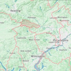
French Creek watershed in southeastern Pennsylvania.
The area of land that drains into streams, lakes, estuaries or other bodies of water are known as watersheds. They are also known as drainage basins or catchments.
As precipitation falls to the ground, the water is pulled downhill by gravity, which causes it to flow over the landscape or infiltrate through the soil into the groundwater.
Topography — the hills, valleys, and other features that define the landscape — determine the boundaries of watersheds.
Every stream, regardless of its size, has a watershed. Smaller watersheds are contained within larger watersheds. For example, the French Creek watershed in southeastern Pennsylvania is part of the Schuylkill watershed, which in turn is part of the Delaware River Watershed, which is part of the Delaware Bay watershed.
Find Your Watershed
No matter where you live, you live within a watershed. Just as you have a home and school address, you also have a watershed address. If you live in the continental United States, you can use Model My Watershed to find your watershed.
*Note: in the United States, watersheds are classified by U.S. Geological Survey Hydrologic Unit Codes (HUCs). The smaller the HUC number, the larger the watershed.
- Go to Model My Watershed. Allow the web app to access your location. (If you want to know the watershed of an address OTHER than your current location, type the address into the search bar near the top right corner of the map.)
- In the “Explore” pane on the left side of your screen, scroll down and click the “Get started” button.
- Click “Select boundary.” We’ll look at your watershed at several scales, starting with the largest HUC.
- First choose the HUC-8 subbasin unit. Place your mouse cursor over your location and you’ll see the HUC-8 subbasin name as a tooltip. HUC-8 subbasins average about 700 square miles in size.
- Next, choose the HUC-10 watershed unit. HUC-10s are smaller than HUC-12s, averaging about 227 square miles. Hover your cursor to see your HUC-10 watershed name.
- Lastly, choose the HUC-12 subwatershed unit option under “Select boundary.” HUC-12 subwatersheds average about 40 square miles in size. Hover your cursor over the map to see your HUC-12 subwatershed name.
In the Model My Watershed screenshots below (click to enlarge), you’ll see that Avondale, Pennsylvania, is in the Brandywine-Christina subbasin, White Clay Creek watershed, and East Branch White Clay Creek subwatershed.
- HUC-8
- HUC-10
- HUC-12
![]()
Model My Watershed is a watershed-modeling web app that allows you to:
- Analyze real land use and soil data in your neighborhood and watershed.
- Model stormwater runoff and water-quality impacts using professional-grade models.
- Compare how different conservation or development scenarios could modify runoff and water quality.
Model My Watershed is just one of the tools available in the WikiWatershed Toolkit, designed to help citizens, conservation practitioners, municipal decision-makers, researchers, educators, and students advance knowledge and stewardship of fresh water. Explore all the tools at WikiWatershed.org.


